File:Portugal Império total.png

File originale (1 425 × 625 pixel, dimensione del file: 29 KB, tipo MIME: image/png)
Dettagli

|
Questa immagine (categorizzazione automatica: historical map) o tutte le immagini in questa categoria o galleria dovrebbero essere ricreate usando grafica vettoriale come file SVG. Questo offre diversi vantaggi: vedi Commons:Media for cleanup per maggiori informazioni. Se è disponibile una versione in formato SVG di questa immagine, per favore caricala. Dopo aver caricato un file SVG, sostituisci questo avviso con il template {{Vector version available|nome_immagine.svg}}.
|
Dettagli
| Descrizione |
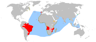
English: An anachronous map of the Portuguese Empire (1415-1999).
Português: Mapa anacrónico do Império Português (1415-1999).
Deutsch: Anachronistische Karte des Portugiesischen Weltreichs (1415-1999)
Español: Mapa anacrónico del imperio portugués (1415-1999).
Français : Carte anachronique de l'empire colonial portugais (1415-1999).
Italiano: Carta anacronistica dell'Impero Portoghese (1415-1999).
Galego: Mapa anacrónico do imperio portugués (1415-1999).
한국어: 포르투갈 제국(1415-1999)의 연대를 무시한 영역 지도.
中文:时间交错的葡萄牙帝国(1415年-1999年)地图,红色代表实际占有领土,粉红色代表勘探地、贸易影响地区以及宣称占有的陆域,蓝色代表勘探海域、航海路线和影响力所及的海域(不包括有争议的澳大利亚的发现)
Polski: Anachroniczna mapa Imperium Portugalskiego (1415-1999).
Kolory:
தமிழ்: போர்த்துகீசிய பேரரசு (1415-1999) காலத்திற்கு ஒவ்வாத வரைபடம்
நிறங்கள்
Bahasa Indonesia: Sebuah peta anakron dari Kekaisaran Portugis (1415-1999).
|
| Data | 30 marzo 2007 (data di caricamento originaria) |
| Fonte | Trasferito da en.wikipedia su Commons. |
| Autore | The Ogre di Wikipedia in inglese / Later versions were uploaded by The Red Hat of Pat Ferrick di Wikipedia in inglese. |
| Altre versioni | Opere derivate da questo file: Portuguese Empire 1415-1999.png |
Additional Information and Sources
This map is a comprehensive geographical anachronous representation of all the actual possessions of the en:Portuguese Empire.
Claims of sovereignty
Areas of discovery
(European discoveries were usually accompanied by ceremonies claiming the newly discovered lands for the monarch in whose name the voyage was made, even if those claims were not followed up by actual colonisation).
- en:Greenland: (1499/1500–?) possession claimed by João Fernandes Labrador in 1499 or 1500. Seen as claimed in the Cantino planisphere of 1502, Reinel-Lopo Homem chart of 1519 and Reinel map of 1535.
- Land of the Corte-Real: (1501–?) claimed after the voyages of the Corte-Real brothers.
- Terra Nova (Newfoundland): (1501–?) claimed by Miguel and Gaspar Corte-Real, latter by João Álvares Fagundes. Also known as Terra Nova dos Bacalhaus.
- en:Labrador (1499/1500–?): claimed by the Corte-Real brothers and maybe by João Fernandes Labrador.
- en:Nova Scotia (1519?–?): explored and claimed by João Álvares Fagundes.
- African coastline
Trading posts
Timisoara gabriel
Areas of influence
Actual posessions
In Africa
Portuguese presence in en:Africa started in 1415 with the conquest of en:Ceuta and is generally view as ending in 1975, with the independence of its later colonies, although the present autonomous region of en:Madeira located in the en:African Plate, some 650 km (360 mi) off the en:North African coast, Madeira belongs and has always belonged ethnically, culturally, economically and politically to en:Europe, some 955 km (583 mi) from the European mainland.
- Angola/Portuguese West Africa: colony (1575–1589); crown colony (1589–1951); overseas province (1951–1971); state (1971–1975). Independence in 1975.
- en:Arguin/Arguim: (1455–1633)
- en:Accra: (1557–1578)
- Cabinda: protectorate (1883–1885)Frente de Libertação do Estado de Cabinda (F.L.E.C). Congo district (1887–1921); intendancy subordinate to en:Maquela (1921–1922); dependency of Zaire district (1922–1930); Intendacy of Zaire and Cabinda (1930–1932); intendancy under en:Angola (1932–1934); dependency under Angola (1934–1945); restored as District (1946–1975). Controlled by Frente Nacional para a Libertação de Angola (en:National Liberation Front of Angola) as part of independent Angola in 1975. Declared Cabinda a Republic in 1975, but not recognized by Portugal nor Angola.
- Cabo Verde/Cape Verde: settlements (1462–1495); dominion of crown colonies (1495–1587); crown colony (1587–1951); overseas province (1951–1974); en:autonomous republic (1974–1975). Independence in 1975.
- en:Ceuta: possession (1415–1640). Became Spanish in 1668.
- en:Elmina: possession (1482–1637)
- Fernando Poo and en:Annobón: colonies (1474–1778). Ceded to Spain in 1778.
- en:Portuguese Gold Coast: (1482–1642), ceded to Dutch Gold Coast in 1642
- Guiné Portuguesa/Portuguese Guinea: colony (1879–1951); overseas province (1951–1974). Unilateral independence declared in 1973, recognized by Portugal in 1974.
- en:Madagascar: southern part (1496–1550)
- en:Madeira: possession (1418–1420); colony (1420–1580); crown colony (1580–1834); autonomous district (1834–1976). Made an autonomous region in 1976.
- en:Mascarene Islands: fortified post (1498–1540)
- en:Malindi: occupation (1500–1630)
- en:Mombassa: occupation (1593–1638); colony subordinate to Goa (1638–1698; 1728–1729). Under Omani sovereignty in 1729.
- en:Morocco en:enclaves
- Aguz/en:Soueira Kedima (1506–1525)
- en:Tânger/Tanjah (1471–1661). Ceded to en:England in 1662.
- en:Alcácer Ceguer/El Qsar es Seghir (1458–1550)
- en:Arzila/en:Asilah (1471–1550; 1577–1589). Conquest by Saady in 1589.
- en:Azamor/Azemmour (1513–1541). Conquest by Saady in 1541.
- en:Mazagão/El Jadida (1485–1550); possession (1506–1769). Anexed by Morocco in 1769.
- en:Mogador/Essaouira (1506–1510)
- Safim/Safi (1488–1541) Conquest by Saady
- Santa Cruz do Cabo de Gué/en:Agadir (1505–1541) Conquest by Saady
- Mozambique/Portuguese East Africa: possession (1498–1501); subordinate to Goa (1501–1569); captaincy-general (1569–1609); colony subordinate to Goa (1609–1752); colony (1752–1951); overseas province (1951–1971); state (1971–1974); local transitional administration (1974–1975). Independence in 1975.
- Quíloa (1505–1512)
- en:Saint Laurent Islands (Madagascar): fortified post (1498–1540)
- en:São João Baptista de Ajudá: fort subordinate to Brazil (1721–1730); subordinate to São Tomé e Príncipe (1865–1869). Annexed by Dahomey in 1961.
- São Tomé e Príncipe: crown colony (1753–1951); overseas province (1951–1971); local administration (1971–1975). Independence in 1975.
- en:São Tomé: possession (1470–1485); colony (1485–1522); crown colony (1522–1641); administration under Dutch occupation (1641–1648). French occupation in 1648.
- en:Príncipe: colony (1500–1573). United with São Tomé in 1573.
- en:Zanzibar: possession (1503–1698). Became part of en:Oman in 1698.
- en:Ziguinchor: possession (1645–1888). Ceded to en:France in 1888.
North Atlantic and North America
The Azores were discovered soon in the Discovery Ages. Labrador and Corte-Real brothers later explored and claimed Greenland and eastern modern Canada from 1499 to 1502.
- en:Azores: colonies (1427–1766); captaincy-general (1766–1831); autonomous districts of en:Angra do Heroismo, en:Horta and en:Ponta Delgada (1831–1976). Made an autonomous region in 1976.
In Central and South America
Brazil was explored and claimed in 1500, and become independent in 1822. Unlike the Spanish, the Portuguese did not divide its possession in South America in several vice-royalties.
- en:Barbados: Possession known as Os Barbados, discovered by Pedro Campos in 1536 being an exile post for Brazilian Jews. The only Caribbean possession the Portuguese held for eighty-four years until Portugal abandoned the island to continue exploring nearby Brazil.
- en:Brazil: possession known as Ilha de Santa Cruz, later Terra de Vera Cruz (1500–1530); colony (1530-1714); vice-kingdom (1714–1815); kingdom under United Kingdom of Portugal (1815–1822), independence in 1822.
- Cisplatina (Uruguay): occupation (1808–1822). Captaincy in 1817 (of the United Kingdom of Portugal, Brazil and Algarves). Adhered as a province of the new en:Empire of Brazil in 1822. Became independent 1827, changing its name to Uruguay.
- en:French Guiana: occupation (1809–1817). Restored to en:France in 1817.
- Nova Colônia do Sacramento: colony in present Uruguay (1680; 1683–1705; 1715–1777). Ceded to Spain in 1777.
In Asia and Oceania
Reached by the Portuguese in 1498 by en:Vasco da Gama. Macau was the last possession in Asia and was handed over to the People's Republic of China in 1999.
- en:Aden: possession (failed in 1510;1516-1538)
- en:Bahrain: possession (1521–1602)
- Ceylon: colony (1597–1658). Dutch took control in 1656, en:Jaffna taken in 1658.
- Flores Island: possession (16th-19th century)
- en:Solor: possession (1520-1636)
- Gamru/en:Bandar Abbas: possession (1506–1615)
- en:Hormuz/Ormuz: possession subordinate to Goa (1515–1622). Incorporated into Persia in 1622.
- Laccadive Islands (1498–1545)
- en:Macau/Macao: settlement (1553–1557), leased territory subordinated to Goa (1557–1844); overseas province (1844–1883); combined overseas province with Timor-Leste under Goa (1883–1951); overseas province (1951–1976); Chinese territory under Portuguese administration (1976–1999). Returned to full sovereignty of People's Republic of China as a en:special administrative region in 1999.
- en:Coloane: occupation in 1864
- en:Taipa: occupation in 1851
- en:Ilha Verde: incorporated in 1890
- D. João, Lapa and Montanha Islands: settled by Portuguese missionaries in the XIX century; occupation by Portuguese troops in 1938. Taken in 1941 by the en:Empire of Japan and restored to China in 1945.
- en:Makassar (1512–1665)
- en:Malacca: settlement (1511–1641); lost to the Dutch
- en:Maldives: possession (1518–1521, 1558–1573)
- en:Moluccas
- Amboina/Ambon: settlement (1576–1605)
- en:Ternate: settlement (1522–1575)
- en:Tidore: colony (1578–1605). Seized by Dutch in 1605.
- Muscat: possession (1515–1650)
- Índia Portuguesa/Portuguese India: overseas province (1946–1962). Taken over by India in 1962 and recognised by Portugal in 1974.
- Baçaim/en:Vasai: possession (1535–1739)
- en:Bombay/en:Mumbai: possession (1534–1661)
- en:Calicut/en:Kozhikode: settlement (1512–1525)
- en:Cambay/en:Khambhat: possession
- en:Cannanore: possession (1502–1663)
- en:Chaul: possession (1521–1740)
- en:Chittagong: possession (1528–1666)
- Cochin: possession (1500–1663)
- en:Cranganore: possession (1536–1662)
- Damão/Daman: acquisition in 1559. Became part of overseas province in 1946. Retaken over by India in Dec 1961.
- Diu: acquisition in 1535. Became part of overseas province in 1946. Retaken over by India in Dec 1961.
- en:Dadra: acquisition in 1779. Retaken over by India in 1954.
- en:Goa: colony (1510–1946). Became part of overseas province in 1946. Retaken over by India in Dec 1961.
- en:Hughli: possession (1579–1632)
- Nagar Haveli: acquisition in 1779. Retaken over by India in 1954.
- Masulipatnam (1598–1610)
- en:Mangalore (1568–1659)
- en:Negapatam/en:Nagapattinam (1507–1657)
- Paliacate (1518–1610). occupied by the Dutch in 1610.
- Coulão/en:Quilon: possession (1502–1661)
- en:Salsette Island: possession (1534–1737). conquered by the en:Marathas.
- en:São Tomé de Meliapore: settlement (1523–1662; 1687–1749)
- en:Surat: settlement (1540–1612)
- en:Tuticorin/en:Thoothukudi (1548–1658)
- en:Socotra: possession (1506–1511). Became part of Mahri en:Sultanate of Qishn and Suqutra
- en:Timor: claimed and partially possessed from 1520 to 1640.
- en:West Timor: part of Timor lost to the Dutch in 1640.
- en:East Timor: colony subordinate to Portuguese India (1642–1844); subordinate to Macau (1844–1896); separate colony (1896–1951); overseas territory (1951–1975); republic and unilateral independence proclaimed, annexed by Indonesia (1975–1999, UN recognition as Portuguese territory). UN administration from 1999 until independence in 2002.
References
- ↑ https://books.google.com/books?id=vtZtMBLJ7GgC&pg=PA92&dq=Canary+Islands+Portuguese+claim#PPA93,M1
- ↑ https://books.google.com/books?id=wP5gjdGinkwC&pg=PA11&dq=pink+map+portuguese
Licenza
| Quest'opera è stata rilasciata nel pubblico dominio dal suo autore, The Ogre di Wikipedia in inglese. Questa norma si applica in tutto il mondo. In alcuni paesi questo potrebbe non essere legalmente possibile. In tal caso: The Ogre garantisce a chiunque il diritto di utilizzare quest'opera per qualsiasi scopo, senza alcuna condizione, a meno che tali condizioni siano richieste dalla legge. |
Registro originale del caricamento
- 2007-04-16 16:58 The Ogre 1425×625×8 (44511 bytes) corrected map regarding Formosa/Taywan
- 2007-04-15 13:11 The Ogre 1425×625×8 (44415 bytes) rm question smarks in North America as per talk in [[Talk:Portuguese_Empire#An_exploration_.3D_Empire.3F|Talk:Portuguese Empire # An exploration = Empire?]]
- 2007-04-09 20:29 The Ogre 1425×625×8 (44551 bytes) An anachronous map of the [[Portuguese Empire]] (1415-1999). Red - actual possessions; Pink - explorations, areas of influence and claims of sovereignty; Blue - main sea explorations, routes and areas of inluence.
- 2007-04-03 23:35 The Red Hat of Pat Ferrick 1425×625×8 (29727 bytes) Removed Australia as per talk page.
- 2007-04-03 15:20 The Ogre 1425×625×8 (44746 bytes) I made this, again and again... It´s a work in progress! Just corrected the color (red to Pink) for the [[Banda Islands]]
- 2007-03-31 16:02 The Ogre 1425×625×8 (44736 bytes) Again me, some minor tweaks.
- 2007-03-31 12:59 The Ogre 1425×625×8 (43961 bytes) I made this, once more! Adding Portuguese area of influence in the [[Kingdom of Kongo]]
- 2007-03-30 17:55 The Ogre 1425×625×8 (43701 bytes) I made this, again!
- 2007-03-30 17:42 The Ogre 1425×625×8 (43664 bytes) I made this!
Licenza

|
Il detentore del copyright di quest'opera ne autorizza l'uso a chiunque per qualsiasi scopo, senza restrizioni, inclusa la ridistribuzione, l'uso commerciale e la modifica.
Note d'uso: |
References
- Diffie, Bailey (1977) Foundations of the Portuguese Empire, 1415-1580, University of Minnesota Press ISBN: 0816607826.
Cronologia del file
Fare clic su un gruppo data/ora per vedere il file come si presentava nel momento indicato.
| Data/Ora | Miniatura | Dimensioni | Utente | Commento | |
|---|---|---|---|---|---|
| attuale | 14:53, 25 lug 2010 | | 1 425 × 625 (29 KB) | wikimediacommons>The Ogre | Sorry, rv, the previous maps shows more detail and is not incorrect - Reverted to version as of 13:30, 25 January 2009 |
Utilizzo del file
Le seguenti 2 pagine usano questo file: