File:Via Egnatia-en.jpg
Vai alla navigazione
Vai alla ricerca

Dimensioni di questa anteprima: 733 × 600 pixel. Altre risoluzioni: 293 × 240 pixel | 587 × 480 pixel | 939 × 768 pixel | 1 100 × 900 pixel.
File originale (1 100 × 900 pixel, dimensione del file: 420 KB, tipo MIME: image/jpeg)
Dettagli
| Descrizione |
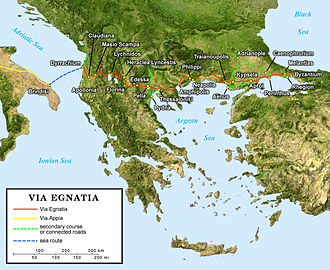
English: English map of the ancient Roman Via Egnatia crossing the South of the Balkans.
Français : Carte en anglais de l'antique Via Egnatia romaine traversant le sud des Balkans.
Deutsch: Englische Karte der Via Egnatia (griechisch Ἐγνατία Ὁδός) eine römische Straße die Adriaküste mit dem Bosporus verband |
||
| Data | |||
| Fonte |
Own work; |
||
| Autore | Eric Gaba (Sting - fr:Sting) | ||
| Licenza (Riusare questo file) |
|
||
| Altre versioni |
[]
|


Licenza
Io, detentore del copyright su quest'opera, dichiaro di pubblicarla con la seguente licenza:
Questo file è disponibile in base alla licenza Creative Commons Attribuzione-Condividi allo stesso modo 2.5 Generico
- Tu sei libero:
- di condividere – di copiare, distribuire e trasmettere quest'opera
- di modificare – di adattare l'opera
- Alle seguenti condizioni:
- attribuzione – Devi fornire i crediti appropriati, un collegamento alla licenza e indicare se sono state apportate modifiche. Puoi farlo in qualsiasi modo ragionevole, ma non in alcun modo che suggerisca che il licenziante approvi te o il tuo uso.
- condividi allo stesso modo – Se remixi, trasformi o sviluppi il materiale, devi distribuire i tuoi contributi in base alla stessa licenza o compatibile all'originale.
Cronologia del file
Fare clic su un gruppo data/ora per vedere il file come si presentava nel momento indicato.
| Data/Ora | Miniatura | Dimensioni | Utente | Commento | |
|---|---|---|---|---|---|
| attuale | 22:55, 10 giu 2006 | | 1 100 × 900 (420 KB) | wikimediacommons>Sting | {{Information |Description=Map of the antic Roman Via Egnatia crossing the South of the Balkans |Source=''For the source of data and the modern name of the cities, see the'' '''[[|discussion page]]''' |Date= June 2006 |Author= Eric Gab |
Utilizzo del file
Le seguenti 2 pagine usano questo file: